Adriatic-Alpine Exploration Journal • Edition 2026

Where Limestone Massifs Plunge into the Adriatic Waters.

An editorial monograph cataloging Montenegro’s untamed wilderness: from luminous sea-caves in Luštica to 2,500m glacial cirques in Durmitor and the forgotten stone hamlet of Gornji Stoliv.

293km Adriatic Shoreline
18 Glacial Mountain Eyes
1,300m Tara Canyon Depth
04 UNESCO Natural Sanctuaries
Spatial Depth Projection

The Geological Collision: Coast Meets 2,500-Meter Limestone

Manipulate the spatial topographical simulation below. Drag to orbit terrain angles across the Bay of Kotor and the Durmitor mountain massif.

COORDINATES: 42.4247° N, 18.7712° E
ELEVATION SHIFT: 0m → 2,523m (Bobotov Kuk)
STATUS: ACTIVE RENDERING
✦ Click and drag to orbit terrain angle | Hover to manipulate light
Curated Field Dossiers

Four Prime Landscapes of Montenegro

Every route is documented with field elevation profiles, exact water depth coordinates, local maritime customs, and seasonal access windows.

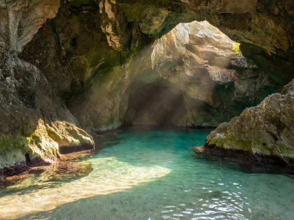
Sunlight beaming into secret sea caves of Lustica Peninsula Montenegro
01
Adriatic Coast Marine Sanctuary
COASTAL SECTOR • LUŠTICA
Elevation: 0m — 85m | Water Clarity: 24m

The Blue Caves of Luštica & Forgotten Submarine Vaults

Carved by millenniums of pounding southern Adriatic swell, the limestone cliffs of Luštica hide sub-surface azure caverns and Cold War era naval sea-tunnels swallowed by wild fig vines and salt spray.

Sea Temp 24.5°C Summer
Access Sea Kayak / Rib
Best Window 07:00 – 11:30 AM
Read Coastal Dossier 7 Min Field Guide
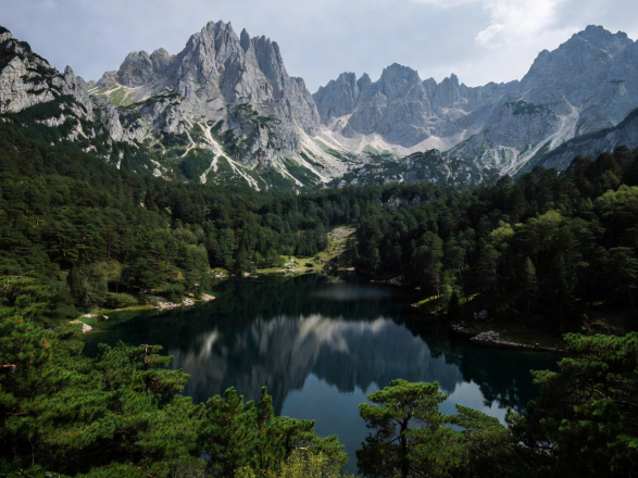
Crno Jezero Black Lake surrounded by dense pine forests and jagged peaks in Durmitor National Park Montenegro
02
Durmitor Massif Glacial Basin
ALPINE SECTOR • ŽABLJAK
Elevation: 1,416m — 2,523m | 18 Glacial Eyes

Black Lake & The Glacial Throne of Bobotov Kuk

Above the clouds in the northern highlands, Durmitor National Park preserves primeval forests and eighteen crystal-clear glacial tarns known locally as 'Gorske Oči' (Mountain Eyes), watched over by limestone pyramids.

Trek Difficulty Demanding Alpine
Peak Height 2,523m Summit
Best Window June – October
Read Summit Dossier 9 Min Alpine Guide
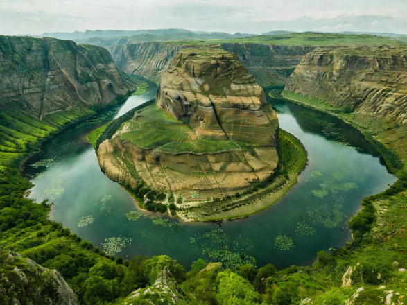
Winding horseshoe bend of Rijeka Crnojevica and Lake Skadar Montenegro with lily pads
03
Skadar Wetlands Balkan Amazon
WETLAND SECTOR • VIRPAZAR
Elevation: 6m — 44m | 280+ Avian Species

Pavlova Strana Horseshoe & The Wild Skadar Reeds

The largest lake in the Balkans resembles a flooded mountain range. Carpeted in white water lilies and home to the endangered Dalmatian Pelican, its serpentine river curves create Montenegro’s most hypnotic panorama.

Pelican Colony Native Breeding
Waterway Traditional Čun Boat
Best Window Sunrise / Sunset
Read Skadar Monograph 6 Min Wetland Guide
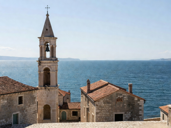
Ancient Venetian stone architecture and bell tower overlooking Adriatic waters in Montenegro
04
Vrmac Ridge Venetian Heritage
HERITAGE SECTOR • STOLIV
Elevation: 240m | Centuries-Old Chestnut Groves

Gornji Stoliv: The Ghost Stone Hamlet on Mount Vrmac

Accessible only by a hand-laid medieval stone staircase through a canopy of 500-year-old sweet chestnut trees, Gornji Stoliv is a silent Venetian village perched high above the shimmering inner fiord of Boka Kotorska.

Ascent Time 45 Min Stairway
Population 2 Permanent
Atmosphere Stone Sanctuary
Read Settlement Report 8 Min Field Dossier
Topographical Traversal

The Grand Adriatic-to-Alps Continuum

Montenegro is one of the few places on earth where you can kayak in warm Mediterranean saltwater in the morning and hike across glacial snowmelt fields before dusk.

Stage 01

Bay of Kotor & Perast

Venetian Baroque palaces, twin islet monasteries, and vertical limestone walls rising 1,000m sheer from the water.

Marine Altitude 0m
Stage 02

Lovćen Serpentine Ladder

25 hairpin curves engineered in 1884, revealing the entirety of Boka Bay like a bird’s eye topographical relief.

Climbing to 1,749m
Stage 03

Tara River Canyon

The deepest river canyon in Europe (1,300m) carved into wild karst gorges, spanned by the colossal Đurđevića bridge.

Karst Canyon 800m
Stage 04

Prokletije Accursed Peaks

The jagged, untamed frontier of southeastern Europe featuring razor-sharp dolomitic spires and untouched glacial cirques.

High Wilderness 2,694m
Field Journal & Logbooks

Essential Montenegro Field Intelligence

Expedition Briefing
Crno Jezero Black Lake and Durmitor high pass trails in Montenegro Durmitor Highlands
HIGH PASS DOSSIER

Navigating the P14 Durmitor Ring Route

A comprehensive breakdown of Montenegro’s most dramatic alpine high pass: Sedlo col, single-lane etiquette, and Bobotov Kuk trailheads.

Read Field Guide →
Ancient stone church bell tower and coastal heritage in Gornji Stoliv Montenegro Vrmac & Stoliv Heritage
HERITAGE ARCHIVE

The 500-Step Stone Stairway of Mount Vrmac

Investigating the hand-hewn Venetian steps, sacred chestnut groves, and forgotten stone olive presses of Gornji Stoliv.

Read Field Guide →
Winding river curve of Lake Skadar wetlands in Montenegro Skadar Waterways
WETLAND EXPEDITION

Pavlova Strana & The Balkan Amazon

Navigating the labyrinthine river channels, traditional wooden čun boats, and endangered pelican sanctuaries of Lake Skadar.

Read Field Guide →
The Adriatic Frontier Awaits

Plan Your Autonomous Montenegrin Field Exploration

Access high-resolution GPS tracks, permit guidelines for national parks, boat mooring contacts in Boka Bay, and local high-pasture shepherd homestays.